Tropical Storm Rachel is forecast to bring coastal flooding, gusty winds and rain to Ventura County starting Saturday, Oct. 10. If Rachel makes landfall as a tropical storm, it would be the first to do so in California since 1939, according to Patch, citing AccuWeather.
Sunday, Oct. 11, is expected to be the worst day.
"It looks like Sunday is probably going to be the worst of it in terms of the combination of everything: surf, tides, winds, even rain," Bryan Lewis, a meteorologist with the National Weather Service (NWS) Los Angeles/Oxnard office, told Patch on Thursday, Oct. 8.
The NWS has issued a Coastal Flood Advisory for Ventura County beaches, the Malibu Coast, Los Angeles County beaches and Catalina and Santa Barbara islands. The advisory runs through 2 p.m. Tuesday, Oct. 13.
What to expect
The advisory warns of minor to moderate coastal flooding, with isolated significant flooding possible on Sunday. High tides of 7.0 to 7.6 feet are expected each morning. The greatest risk comes Sunday morning, when extreme tides, large waves and strong winds could all peak at the same time, according to the NWS.
Seawater could flood low-lying coastal areas around high tide, including beach parking lots, bike paths and harbor walkways, the advisory states. Moderate to significant beach erosion is also likely.
The Los Angeles Times reported that the coastline from Malibu to Ventura is particularly at risk. NWS meteorologist Ryan Kittell told the Times that tides are running 1 to 1.5 feet above normal because of El Niño-warmed ocean temperatures, compounding the flood risk.
Kittell said there is a 70% to 90% chance of rain between Saturday and Tuesday in Los Angeles and Ventura counties. The highest chances fall between Sunday night and Monday night. The NWS Los Angeles/Oxnard office said there is a 10% chance of thunderstorms.
For Los Angeles County, Lewis said the most likely rainfall totals range from a quarter-inch to three-quarters of an inch, with higher amounts possible in the mountains. Rain rates are expected to stay at a quarter-inch per hour or less, making debris flows and landslides unlikely for the area, Kittell told the Times.
Sunday is also expected to be the windiest day, with south-to-west gusts of 20 to 35 mph, according to Kittell.
Storm position
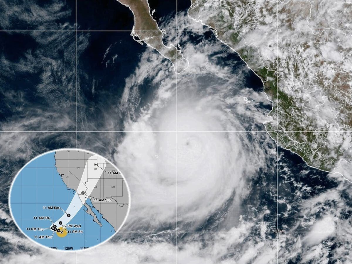
As of 2 a.m. Thursday, the National Hurricane Center reported Rachel had maximum sustained winds of 70 mph and was located about 895 miles west of the southern tip of Baja California. The storm is expected to continue weakening as it approaches.
Lewis told Patch the storm's path is trending farther south than earlier forecasts suggested. He said Rachel does not look like Tropical Storm Hilary in 2023, calling the expected local impacts "a few steps down at least."
The storm will also end the region's October heat wave. Temperatures that reached 95 to 105 degrees on Thursday are expected to drop into the 70s by Sunday or Monday, according to the NWS.
How Camarillo and Moorpark residents can prepare
The City of Camarillo's emergency preparedness page advises residents to clear leaves and debris from gutters, downspouts and storm drains. Residents in flood-prone areas should keep sandbags or other flood-prevention materials on hand. Sandbag station locations are listed at the Ventura County Fire Department's website.
The city also recommends securing outdoor furniture and loose items, and signing up for emergency notifications through VCAlert.
Lewis warned that even modest rainfall can cause localized street flooding in Southern California. The NWS advisory urges residents to stay out of the water, avoid rock jetties and never drive through flooded roads.
Residents can track Rachel's path through the National Hurricane Center and find local forecasts through the NWS Los Angeles/Oxnard office.